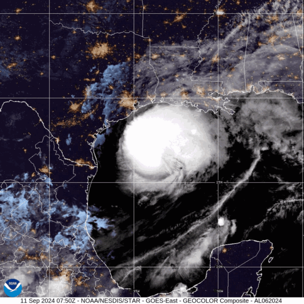
Hurricane Francine is closing in on Louisiana with high winds and dangerous storm surge, picking up speed as it nears the coast.
Francine is a Category 1 hurricane with top winds holding steady at 90 miles (145 kilometers) per hour, the US National Hurricane Center said in an advisory at 10 a.m. local time. The storm is no longer forecast to reach Category 2 strength on the five-step Saffir-Simpson scale. It’s heading for a marshy stretch of coastline about 70 miles west of New Orleans, where it’s expected to come ashore later on Wednesday.
“It will make landfall kind of in the no man’s land of Louisiana,” said Adam Douty, a meteorologist with AccuWeather Inc.
Wind gusts in New Orleans could reach 60 mph. The storm has grounded 233 flights in Houston, New Orleans and Baton Rouge, according to FlightAware, an airline tracker.
Oil and gas companies have evacuated some offshore platforms in the Gulf of Mexico. While the storm is not forecast to make a direct hit on any of the region’s major natural gas export plants, gas feeding into Sempra’s Cameron terminal has declined ahead of Francine.
Francine is set to pummel the region with heavy rains, creating the risk for flash and urban flooding, the hurricane center said. Storm surge in some areas could reach 10 feet (3 meters).
After making landfall, the storm is forecast to move across Mississippi on Thursday and head north toward Memphis. While there may be some flooding, the rains will bring some relief to the Mississippi River, where low water levels have threatened to roil shipments of everything from corn to gasoline. But rains will make field work harder, delaying harvests and reducing grain quality.
Francine will likely cause between $2 billion and $3 billion in damages and losses, said Chuck Watson, a disaster modeler with Enki Research. Francine will be the third hurricane to hit the US mainland this year.
The hurricane center is tracking three other disturbances in the central Atlantic Ocean that have potential to become tropical storms. One of the systems has been upgraded to a tropical depression and will likely be named Tropical Storm Gordon overnight. It’s currently more than 300 miles west of the Cabo Verde Islands off the coast of Africa.


 AIG, Chubb Can’t Use ‘Bump-Up’ Provision in D&O Policy to Avoid Coverage
  Earnings Wrap: With AI-First Mindset, ‘Sky Is the Limit’ at The Hartford
  Preparing for an AI Native Future
  What Analysts Are Saying About the 2026 P/C Insurance Market
