On July 15, a well-organized thunderstorm rolled across Iowa, Illinois and parts of Indiana, according to the National Weather Service.
Wind speeds of 60-100 mph were observed within the line, especially from eastern Iowa, northern Illinois and central Illinois.
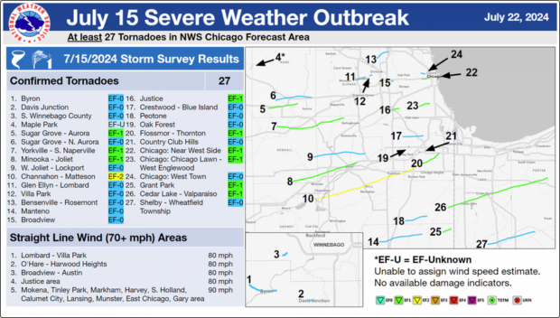
With 27 recorded tornadoes, this storm breaks the previous daily record for tornadoes in the forecast area (June 30, 2014 “Double Derecho” and March 31, 2023 Outbreak).
Additional tornadoes may be added as the NWS continues to analyze reports and data related to this widespread storm.
Derechoes develop in environments with very warm and moist air at the surface, relatively cooler air aloft, and strong winds at the upper levels of the atmosphere, the NWS explained.
Northern Illinois and Indiana are within a region where derechoes are common, averaging one derecho every year.
Derechoes as strong as the one that impacted the area on July 15 have an occurrence interval of once every 5 to 10 years.
Wind speeds in derechoes often exceeds 100 mph in hardest-hit areas, the NWS reported.
Some of the strongest derechoes have produced wind speeds estimated to exceed 120 mph.
A derecho produces a swath of particularly damaging thunderstorm winds (specifically, wind gusts of at least 58 mph along most of its length with several well-separated 75 mph or greater gusts) over an area at least 250 miles long, the weather agency explained.
The majority of winds are not caused by tornadoes within the line, but tornadoes are common within derechoes.
 Experts Say It’s Difficult to Tie AI to Layoffs
  Modern Underwriting Technology: Decisive Steps to Successful Implementation
  Five AI Trends Reshaping Insurance in 2026
  Flood Risk Misconceptions Drive Underinsurance: Chubb